| A Brief History of 'Hillsdale County' |
| Pioneer Period: 1825-1843 |
| Edited and © 1999 by Dan Bisher |
| This is a story of travel by water and land around and through trackless forest and winding rivers to claim new nations, new territories in the name of God, kings and individuals, one of bold adventure, trade and war, and, finally, settlement and civilization. It remains an epic tale of our ancestors and their sacrifice and struggle to establish an existence in wild, untamed and often inhospitable places. From virgin old growth hardwoods, these strong and principled people carved humbled farms, busy villages and vibrant towns. Today, we call that place Hillsdale County, Michigan. Although filled with glacial debris from the last ice age, this south-central Michigan county retained prime soil for growing crops, an all important consideration for early 19th century peoples dependent upon an agriculturally-based society. For three-fourths of the year during the spring, summer and autumn, southern Michigan is lush green peppered with colors of striking contrast. Some long-time residents have called Hillsdale County "the cradle," meaning it's a place they seldom want to be far from for any length of time. At this writing, the population has grown to nearly 50,000. People have prospered in this place, but our civilization wasn't the first to make homes in the hills and dales. Located in the central part of the southern tier of lower Michigan counties, Hillsdale County was named for the terrain which features "hills and dales." A "dale" is a valley, or an elongated depression of the earth's surface commonly situated between ranges of hills or mountains. Although there are no mountains in Hillsdale County, there are heights that rise 1,250 feet above sea level giving life to the headwaters for five major rivers that drain into Lake Erie and Lake Michigan. Topographical maps indicate that the highest point in the county is located at the corners of Wood and Kelso Roads in Adams Township. As a major watershed with more than 100 lakes, and as many ponds, the rivers that begin within the county's borders include the St. Joseph flowing into Lake Michigan, the St. Joseph of the Maumee, the Kalamazoo, the Grand and the Raisin. Spring fed, the rivers flow north, south, east and west from the highlands. The county is bounded on the north by Calhoun and Jackson Counties, on the east by Lenawee County, on the west by Branch County and Steuben County Indiana. The extreme southwest corner of Hillsdale County is where three states of Michigan, Ohio and Indiana meet, the only place where Michigan borders two other states. On maps, the county is situated at 42" north latitude and 84"30' west longitude, and comprises about 617 square miles, or 394,880 acres. The land lies an average of 630 feet above Lake Erie and 616 feet above Lake Michigan. For centuries prior to the 1820s, Hillsdale County was familiar to generations of Native Americans. From Mastodon and Woolly Mammoth hunters of the post-ice age era to the mound- building Hopewell and Adena cultures of the pre-Columbus period and to the last tribe of Huron-Potawatomi's, this was an important location within the Great Lakes region. The area was the transportation cross roads of the old Northwest with the intersection of the Maumee Trail, a northern spur of the the Great Trail (Now U.S. 120 in northern Ohio and Indiana) that led from the east coast to the Mississippi and beyond, and the Sauk Trail at approximately the location of present day Allen. The rivers also served as important travel routes and the area comprising present-day Hillsdale County was a major apex of a water system that led from the east coast to the Mississippi and beyond. Long before white settlers began pouring into southern Michigan over the Chicago Military road, known today as US-12, Native Americans from many tribes beat a worn path from the shores of Lake Erie in the east to the sandy beaches of Lake Michigan in the west. For centuries, Indians used this route for hunting, trading and all too often, war. During the middle 1600s, Hillsdale County was undoubtedly a battleground between the British-supplied Iroquois tribes of upstate New York who invaded Potawatomies territory. Hillsdale County's recorded history began in 1825 when the Chicago Turnpike (Sauk Trail) was surveyed. Michigan Militia Captain Moses Allen, an enlisted veteran of the War of 1812, was a member of the original survey crew. At a location that now constitutes the dead-end corner of M- 49 and US-12, there stood an abandoned French fur trader's log cabin. To this lonely outpost in the wilderness Captain Allen moved his family from Monroe in 1827, and thus became the first recorded English-speaking white settler in Hillsdale County. His name is perpetuated in the village of Allen, but it was first known as Allen's Prairie. In 1828, Benaiah Jones brought his family from Painesville, Ohio, and settled on the west bank of the St. Joseph River, starting the first village to be incorporated in Hillsdale County. Jonesville became an important center of civilization in the 1830s. In 1829, Thaddeus Wight arrived to become the first white Hillsdale County farmer. Many others soon arrived and in the fall of 1829, on October 29, the county was named Hillsdale due to the topography of the land, but it was known for purposes of government as Vance Township, Lenawee County. The area was not organized into a county until 1835 when it was officially recognized by the Territorial legislature. The name "Hillsdale" was given on October 29, 1829 by the Legislative Council of the Territory of Michigan. On December 13, 1834, a town meeting convened at the home of James D. Van Hoevenburgh in Jonesville for the purpose of electing a township board and of petitioning the legislature for a county organization. The minutes of that momentous meeting are preserved in the town book of Fayette and included the following resolutions: Resolved unanimously, That the inhabitants will petition the Legislative Council to organize said county. Resolved, unanimously, To divide the county into four townships, each township to consist of one range through the county, range 1 to be called Wheatland...; range 2 to be called Moscow...; range 3 to be called Fayette...; range 4 to be called Allen. A slate of officers was drawn up, not all of whom were confirmed by the Legislative Council. The officials named in the legislative act of organization, February 11, 1835, were: James D. Van Hoevenburgh, sheriff; Chauncey W. Ferris, clerk; James Olds, register; John P. Cook, treasurer; and Lyman Blackmar, probate judge. William A. Fletcher was elected circuit judge. None of these officers was a resident of Jonesville, which become the first county seat by proclamation of Governor Lewis Cass on February 16, 1835. The new townships all held their meetings on April 4, 1835, selecting as the first board of supervisors Herman Pratt of Wheatland; Benjamin Fowle of Moscow; Brooks Bowman of Fayette; and Richard W. Corbus of Allen. The boundaries of the new county were the same as present- day, except for the southern border where a strip of land was lost to Ohio during the "Toledo Strip War." It was not the first war to affect this county, nor the last. In 1832, a company of militia under Major Benaiah Jones from Hillsdale County went to the Black Hawk War, but the war ended by the time the militia reached Niles along the Chicago Military Road. In 1835, the Hillsdale County militia was called out again by 19-year-old Governor Stephen Mason (known as "the boy governor), to assemble in Jonesville for training during the so called "Toledo Strip War." The militia started with 30 men bearing arms in 1832, and in 1837, it was reported there were 750 who reported at Jonesville on a military muster. The 1832 Black Hawk War disturbed the routine of the early pioneers in Hillsdale County, as did the border dispute with Ohio in 1835. That border "war" resulted in a sizable chunk of Hillsdale County lands being taken away to push the northern boundary of Ohio northward, eventually creating the "shoestring" township of Amboy. In return for lost land, Congress awarded Michigan the upper peninsula. During the pioneer era in the county (1825-1843), the county experienced a tremendous growth in population. Writers and historians have assumed that
the modern history of Hillsdale County began with the treaty of Chicago in August of 1821.
However, the Indians testified that the signing of the Treaty of Greenville, Ohio, was the
true opening wedge into Indian lands in southern Michigan, northern Indiana and Ohio. This
treaty was signed at Fort Greenville, Ohio in 1794 by General "Mad" Anthony
Wayne and various Indian chiefs, including the Potawatomi. The Indians admitted that they
had been soundly defeated by General Wayne's federal troops at the Battle of Fallen
Timbers (near present day Maumee, Ohio), and the signing of the treaty of Greenville was
therefore sincere and just. Other treaties, they claimed, were signed under duress and
with drunken Indians pretending to be chiefs when they were not, often signing away lands
over which they themselves had no jurisdiction. Such were the treaties of 1805 and 1807;
1821, 1833, and finally in 1838. Among the Indians reportedly never agreed to relinquish the land was Chief Baw Beese, a Huron-Potawatomi with a Scottish name for half-penny. Baw Beese, a council or peace chief, was one of the Indians of the so-called Huron-Potawatomi who had agreed to a treaty to relinquish land on the Huron and Raisin Rivers and to move west of line running straight north from the flagstaff of Fort Defiance, to a point on the Grand River-a line roughly marking the boundary between what now constitutes Hillsdale and Lenawee counties. In return for this the Baw Beese band was to receive $400 per year forever. The Moquago band at Nottawa Seepe (Near present day Athens, Michigan) was to receive a similar amount. Payments were made at Nottawa Seepe until the Baw Beese band was moved west. Thereafter, only the Moquago band received the payments, the last of which was made in 1910. Consequently, Chief Baw Beese considered himself a landlord and treated the early settlers as his guests, from whom he could and did demand rent. It has also been reported that he attempted to charge the settlers for the water flowing out of Baw Beese Lake. Historical research has revealed long-lost details about Baw Beese and his people. Those first settlers credited Baw Beese and his tribe of about 100 for helping their pioneer families by providing meat and traditional medicinal care through the long hard winters. The Potawatomies were known as successful planters and growers of maize (corn), who fished and hunted in fruitful locations. Baw Beese led his people around the county to three primary spots. The first was near the shores of Baw Beese Lake (supposedly named after the old chief by an early settler, Colonel William Fowler), where they fished; the second was near the corner of Squawfield and Waldron Roads, where they grew maize; and the third was just south of Somerset, where they hunted. The native inhabitants also made excursions into Ohio and Indiana, as well as into neighboring Michigan counties. Most Southern Michigan Indians had been relocated to reservations in Iowa and Kansas by 1838. However, because the majority of settlers in Hillsdale County admired and appreciated the local Indian population, Baw Beese and his people continued to co-exist with their white neighbors until the autumn of 1840. After one of the local pioneer`s wrote a letter to then President William H. Harrison requesting the removal of Baw Beese's people from the land he had rightfully purchased, federal troops were sent to roundup the "Red Men" to be escorted out of the county. It was a sad day when Baw Beese left. Schools were let out to bid the old chief and his people farewell. With Baw Beese driving a horse-drawn buggy in the lead, the federals took the Indians from the camp at Squawfield, through Jonesville and Litchfield to Marshall. From Marshall they went west, then down the Mississippi, up the Missouri River and eventually to a reservation at Council Bluffs, Iowa where Baw Beese feared his mortal enemy, the Sioux. Later, many members of the Hillsdale County band were relocated to the reservation north of Topeka, Kansas. Descendants of Baw Beese's village remained on that Kansas reservation throughout the 19th and 20th centuries. There is some historical evidence that some of the original inhabitants hid in the forests, or were hidden by settlers, and remained in the area. Other reports indicate that small groups of the Indians taken west returned to Hillsdale County and took up the ways of white men, eventually assimilating into the Euro- American culture. Even before the Indians departed, the first school in the county was opened in the tiny settlement of Allen by Hiram Hunt in 1831. A school was also opened in Jonesville in 1832 and was attended by the youngest son of Baw Beese. Jonesville later became the first organized school district in the state. The first English-speaking white settler in what later would become the city of Hillsdale was Jeremiah Arnold, of De Peyster, New York, who arrived in 1834, pitched a tent and then built a log cabin on the site of the present day fairgrounds. In that same year, Chauncey Ferris and John Cook opened a well-stocked store in Jonesville. In 1835, the Jonesville Presbyterian Church was constructed, the first church building in the county. In 1839, the first newspaper, the Hillsdale County Gazette, was published on April 13, by James K. Kinman, an attorney and one of the early pioneers who credited Baw Beese for saving the lives of his sick family during a severe winter. The Whig-Standard, forerunner of The Hillsdale Daily News, did not appear in print until 1846. As an attorney, Kinman later gained fame as the defense council for the notorious international counterfitter, horse thief and outlaw Sile Doty, who was convicted in 1852 in the Hillsdale Circuit court and incarcerated throughout the Civil War in Jackson State Prison. In 1843, the railroad reached Hillsdale from Adrian and the first steam engine of the Erie and Kalamazoo line rolled into the small village. For ten years thereafter, Hillsdale became the "jumping off place" for the wild west until the railroad was continued through to Coldwater and Chicago in 1853. Hillsdale was itself a little wild during that period as rogues and rascals took the trains to the last stop on the line. From that time until the 1950s Hillsdale was known as a railroad center, with as many as 26 passenger trains a day going in and out of the city. The railroad lines passing through the county were known by various names. The Erie and Kalamazoo, the Michigan Southern, the Lake Shore and Michigan Southern, and finally the New York Central. Its subsidiaries or branches, originally independent lines were known as the Detroit, Hillsdale and Indiana, which ran from Ypsilanti to Bankers, and the Fort Wayne, Jackson and Saginaw, later known as the Fort Wayne Branch. In 1844, at Spring Arbor, a group of free-willed Baptist organized and opened a pioneer school of higher education called Michigan Central College. Primarily due to the access of the railroad, the college relocated to Hillsdale in 1853 and was renamed Hillsdale College. Two original Hillsdale settlers served as college trustees for many years. Chauncey Ferris was elected the first treasurer in 1853 and John Potter Cook served for more than 20 years. Jonesville was the site of the first
county seat. Later, during a political battle between Jonesville and Hillsdale, Osseo was
for a brief period the county seat. The issue was settled in 1843 when political power
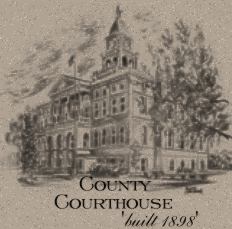
shifted to Hillsdale. The first county courthouse built in 1843 on the current courthouse
square burned in 1847 or 48, destroying most of the county's original documents. A second
courthouse, called the "old stonepile," was constructed in 1850-51 and served
until the current building was constructed in 1898. The first exhibition of the Hillsdale County fair, nicknamed the "Most Popular Fair on Earth," was organized in 1850 and held on the courthouse lawn in 1851. The present fairgrounds now occupies the site of the original plat for the city of Hillsdale, which was removed to the present downtown area. In 1849, a Hillsdale newspaper reported two bears being killed east of the city. It was the last time bears were known to inhabit the county. During the Civil War (1861-1865) hundreds of Hillsdale County residents served in the Grand Army of the Republic. The percentage of male students enlisting from Hillsdale College was higher than that of any other Michigan college and probably higher than that of any non-military college in the North and certainly the American West. Hillsdale, incorporated as a city in 1869, has long been the county's center of commerce and cultural activities. Besides the railroad, many successful businesses have operated here. A gristmill was founded by Cook and Ferris and sold in 1869 to F.W. Stock. Stock's Mill became the largest flourmill east of the Mississippi River and remained so throughout the 20 century, although it was purchased and operated by outside owners such as the Donut Corporation of America and Keary Ingredients. The mill has been an important employer and economic asset to the entire county for more than a century and a half. Since Moses Allen arrived in 1827, Hillsdale County continually played an important role in the history and progress of Michigan and the Great Lakes region in the 19th and 20th centuries.
SOURCES: A 1950s Hillsdale Chamber of Commerce pamphlet prepared by the late Merritt Green. History of Hillsdale County, Michigan; Everts & Abbot, Philadelphia, 1879. 150 Years In The Hills And Dales: A Bicentennial History of Hillsdale County, Michigan Vol. 1, published by The Hillsdale County Historical Society and the Hillsdale County Bicentennial Commission, 1976. The Bean Creek Valley: Incident of its Early Settlement by James J. Hogaboam; Hudson, Michigan; JAS. M. Scarritt, publisher, 1876. History of Michigan by Charles Moore; vol. 1, The Lewis Publishing Company, Chicago, 1915. The Life of Sile Doty: 1800-1876, A Forgotten Autobiography; reprinted edition by Alved of Detroit, Inc., 1948. Michigan Pioneer and Historical Collections, Vol. 14, 1889; Vol. 1, 1874-76. The First People of Michigan by W.B. Hinsdale; George Wahr, publisher, Ann Arbor, 1930. Greater Coldwater Centennial Souvenir Historical Program, 1961. 3,092/3-24-99 |
| [Top of Page] |
Page Updated January 25, 2001